
 By admin
Introduction
Self-driving cars — sometimes called autonomous vehicles (AVs) or autonomous driving systems — are no longer science fiction. Over the past decade they have moved from research labs and pilot projects into commercial trials, robo-taxis, and advanced driver assistance features on consumer cars. At their core, autonomous vehicles must reliably perceive the world, predict what others will do, plan safe trajectories, and physically control the vehicle — all while meeting strict safety, legal, and ethical requirements.
This article explains, in plain but professional terms, how self-driving cars sense and interpret their environment and then avoid collisions with other vehicles, pedestrians, cyclists, and obstacles. It covers the hardware and software building blocks (sensors, mapping, perception, prediction, planning, control), how these components work together to avoid cars and people in real time, industry safety practices and redundancy strategies, current limitations and edge cases, and what the near future is likely to bring. The aim is a modern, SEO-friendly overview targeted at readers who want a comprehensive technical overview without deep math.
1. The Autonomous Driving Stack — A High-Level View
Autonomous driving is best understood as a layered software and hardware stack:
- Sensing: Collect raw data about the environment using cameras, lidar, radar, and ultrasonic sensors.
- Localization & Mapping: Determine the vehicle’s precise position relative to a map (often centimeter-level) and build or use high-definition (HD) maps.
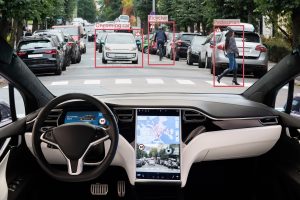
- Perception: Turn raw sensor data into semantic understanding — detect and classify cars, pedestrians, bikes, traffic lights, lane markings, and obstacles.
- Prediction: Forecast the future trajectories and intentions of moving agents.
- Planning: Decide what the vehicle should do (behavioral planning) and compute a safe trajectory (motion planning).
- Control: Execute that trajectory by sending commands to steering, throttle, and brakes.
- Safety & Monitoring: Continuously monitor system health and fall back to safe modes if required.
Each layer is complex and must operate under real-time constraints, often within tens to hundreds of milliseconds.
2. Sensing: The Vehicle’s Eyes and Ears
Robust avoidance begins with high-quality sensing. Modern AVs use a sensor suite to cover different ranges and environmental conditions.
Cameras
Cameras provide high-resolution color images used for object classification, recognizing traffic lights, reading signs, and detecting lane markings. Vision algorithms (deep neural networks for detection and segmentation) extract semantic information from camera frames at 30+ fps. Cameras are inexpensive and rich in detail but sensitive to lighting and weather.
LiDAR (Light Detection And Ranging)
LiDAR emits laser pulses and measures their return times to create a 3D point cloud. It excels at precise distance and shape estimation, enabling accurate obstacle geometry and robust detection at medium ranges (tens to a few hundred meters). Many autonomous systems use multi-beam spinning or solid-state lidar.
Radar
Radar uses radio waves and is excellent at measuring relative velocity via Doppler and performing well in adverse weather (rain, fog). Short- and long-range radars detect moving vehicles and estimate their speed and approximate position. Radar returns are sparse in shape information but invaluable for collision-avoidance logic.
Ultrasonic Sensors
Ultrasonics are used for very short range detection (parking, low-speed maneuvers). They are inexpensive and reliable for close obstacles.
Sensor Fusion
No single sensor is perfect. Sensor fusion algorithms combine camera, lidar, and radar data to produce a more accurate and robust perception result than any individual sensor could. Fusion improves detection reliability in noise, occlusions, and adverse conditions.
3. Localization & High-Definition Maps
To avoid collisions, AVs usually know their own precise location relative to the road and static elements.
GPS + Inertial Measurement
GPS gives global position but is often accurate only to a few meters. Inertial Measurement Units (IMUs) provide short-term motion estimates when GPS is degraded (urban canyons, tunnels).
SLAM & HD Maps
Simultaneous Localization and Mapping (SLAM) and matching to HD maps provide centimeter-level accuracy. HD maps include lane geometry, traffic light locations, crosswalks, curbs, and static obstacles. Matching perception to map data helps predict where pedestrians or vehicles might appear and constrains the planner.
Why Maps Matter
High-definition maps allow the system to anticipate static features (e.g., a tight curb or a pedestrian crossing) and execute smoother, safer maneuvers. Some companies design stack variants that are less map-dependent, but most production systems still rely on map data for redundancy and predictability.
4. Perception — Detecting Cars and People
Perception turns sensor inputs into objects with position, shape, velocity, and class labels.
Object Detection & Tracking
Modern perception uses deep neural networks for object detection (bounding boxes, segmentation masks) on camera images and point clouds. Multi-sensor trackers associate detections across frames to estimate velocity and create persistent tracks for each agent.
Semantic Segmentation
Semantic segmentation labels every pixel (or point) as road, sidewalk, building, or vegetation. This helps locate crosswalks and the drivable surface and reduces false positives.
Pedestrian and Cyclist Specifics
Detecting people and cyclists requires specialized models to recognize diverse poses, clothing, occlusions, and small objects. Infrared or thermal sensors can augment detection at night.
Uncertainty Quantification
Perception algorithms must quantify uncertainty (confidence scores) so the planner can make conservative decisions when sensor data is ambiguous.
5. Prediction — What Will Others Do?
Knowing where others are now isn’t enough; the vehicle must forecast future motion.
Short-Term Trajectories
Prediction algorithms produce likely trajectories for each tracked agent over the next few seconds. Models can be physics-based (constant velocity or acceleration) or learned (recurrent neural networks, transformer models) that use context (lane geometry, interactions).
Intent Prediction
Higher-level intent predictions (e.g., a pedestrian about to cross, a car preparing to merge) use cues such as head orientation, speed, vehicle turn signals, and proximity to crosswalks.
Interaction Modeling
Prediction increasingly models interactions between agents — for example, how one vehicle slowing will influence another’s lane change. These interaction models improve safety in dense traffic.
6. Planning — Deciding Safe Actions
Planning is commonly split into two parts: behavioral (what to do) and motion planning (how to do it).
Behavioral Planning
Behavioral planning decides maneuvers (e.g., keep lane, change lanes, yield, brake). It accounts for traffic rules, social norms, and route goals. Behavior trees, finite state machines, and learned policy networks are used.
Motion Planning
Motion planning computes a feasible trajectory that obeys kinematic constraints and avoids predicted obstacles while optimizing comfort and efficiency. Planners produce smooth paths and velocity profiles and consider worst-case uncertainties from perception/prediction.
Safety Margins
Planners use conservative safety margins around detected agents and account for braking distances, reaction delays, and sensor blind spots.
7. Control — From Plan to Motion
Control systems translate planned trajectories into steering, throttle, and braking commands.
Low-Level Control
Controllers (PID, model predictive control) track the planned path precisely, compensating for vehicle dynamics, road friction, and actuator delays. Tight control is essential during emergency braking or evasive maneuvers.
Emergency Maneuvers
If a collision is imminent, the system executes emergency braking, evasive steering, or a combined maneuver while attempting to minimize harm (e.g., avoiding pedestrians takes precedence over property). Redundant actuators and braking systems ensure the vehicle stops reliably.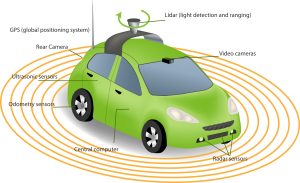
8. How AVs Avoid Cars and People — The Real-Time Loop
Avoidance is the outcome of the entire stack operating in continuous cycles:
- Sense: Cameras/lidar/radar detect objects.
- Fuse & Localize: Sensor fusion reduces false positives; localization confirms position.
- Perceive & Track: Objects are located and tracked with velocities and uncertainty estimates.
- Predict: Future trajectories are forecasted, often with multiple hypotheses.
- Plan: The planner chooses a safe action (slow down, change lane, stop) considering hard constraints (collision avoidance) and soft constraints (comfort).
- Control: Commands are executed and monitored.
To avoid collisions with cars and pedestrians the system uses:
- Conservative speed control in environments with poor visibility or many pedestrians.
- Dynamic safety envelopes — larger buffers for uncertain detections.
- Occlusion reasoning — anticipating agents emerging from behind parked cars or corners.
- V2X (vehicle-to-everything) communications — when available, receiving intent/position from other vehicles or infrastructure to reduce uncertainty.
- Rule-based overrides for critical primitives (e.g., always stop for a pedestrian in a crosswalk).
The loop runs many times per second; latency minimization and synchronized timestamps are crucial.
9. Redundancy, Monitoring & Fail-Safe Design
Safety requires multiple layers of redundancy and continuous monitoring:
- Sensor Redundancy: Multiple sensors covering overlapping fields of view so the system tolerates one sensor failure.
- Compute Redundancy: Duplicate compute paths and watchdogs detect software crashes.
- Diverse Algorithms: Different perception algorithms (e.g., vision and lidar detection) validate each other.
- System Health Monitors: They can trigger minimal risk maneuvers (pull over, stop) when anomalies are detected.
- Regulatory Safety Cases: Companies build evidence and formal safety cases (e.g., ISO 26262, ISO/PAS 21448 — SOTIF) to demonstrate acceptable risk.
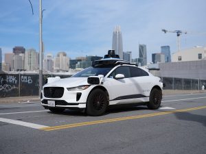
10. Testing, Validation & Real-World Deployment
Real-world avoidance capability is validated through:
- Simulation: Massive scenario testing at scale, including rare events.
- Closed-Course Testing: Controlled environments for boundary-case maneuvers.
- Pilot Fleets: Gradual deployment with remote monitoring and human supervisors on board or teleoperation fallback.
- Shadow Mode: Systems run invisibly in vehicles to compare their decisions to human drivers before full activation.
Rigorous validation is required because the long tail of rare, complex situations (children chasing a ball, unexpected road debris, unusual driver behavior) is extensive.
11. Limitations & Edge Cases
Despite rapid progress, autonomous systems face challenges:
- Adverse Weather: Heavy rain, snow, fog, and glare can degrade sensors. Radar helps but has limited angular resolution.
- Poor or Missing Road Markings: Localization and perception struggle without clear lanes or signage.
- Unstructured Environments: Construction zones, informal pedestrian behavior, and off-road scenarios increase uncertainty.
- Rare Human Behaviors: Jaywalking, sudden double-parked vehicles, or cyclists weaving unpredictably challenge prediction models.
- Ethical & Legal Ambiguity: Decision tradeoffs in unavoidable crash scenarios remain contentious.
Manufacturers mitigate these by conservative design, geofencing (operating only where the system is validated), and human oversight.
12. Regulations, Ethics & Social Acceptance
Regulation varies by jurisdiction; many countries require extensive testing logs, safety cases, and limited operational design domains (ODDs). Ethical questions (e.g., how to weigh harm in unavoidable accidents) drive policy discussions, and social acceptance depends on demonstrable safety improvements and transparency.
13. Emerging Trends and The Road Ahead
Key trends shaping future avoidance capabilities:
- Improved Perception Models: Larger, multimodal models combining vision, lidar, and radar for richer understanding.
- Edge AI and Faster Compute: Lower latency decision-making enabling quicker reactions.
- V2X and Infrastructure Sensing: Smart intersections and connected vehicles sharing intent to reduce uncertainty.
- Formal Verification & Explainable AI: Better tools to certify safety and explain decisions.
- Shared Data & Federated Learning: Cross-fleet learning for faster exposure to rare events.
Together these trends aim to broaden the operational domain and reduce edge-case failures.
Conclusion
Self-driving cars avoid other vehicles and people by combining high-quality sensing (camera, lidar, radar), precise localization and maps, robust perception and prediction, conservative and optimized planning, and reliable control — all wrapped in layers of redundancy and continual safety monitoring. While technical and societal challenges remain, steady improvements in sensors, AI, simulation, and regulation are making autonomous driving safer and more capable each year. When deployed responsibly within well-defined operational domains and with rigorous validation, AVs have the potential to significantly reduce traffic injuries and improve mobility — provided we keep safety as the prime design constraint.